How to Search for a Tax Record
Simple Search
The most common search requests can be satisfied by using this applications Search page.
Simple search is used for performing the most common search request.
Use the Simple search option to find land records based on a single criteria.
As in internet searches, specific data can be found by refining consecutive runs.
Search Criteria Definitions
Parcel ID
10 Digit Number used by the Tax Department to identify a parcel.
Sometimes called the PIN, this number is not to be confused with the Parcel Identifier (see Deed/Book/Page below)
Owner Name
Account name of the land owner. As in other searches, this one is not case-sensitive.
You may enter the last name only to get a list of all property owners with that last name.
Property Address
Property Address is, of course, the street address of the property.
The search engine is not case sensitive. If you are unsure of the exact
property address, you may enter the street name only to get a list of all properties on that street.
Map/Block/PIN
The Map/Block/PIN is a 15 Digit land record ID also called "Parcel Identifier".
It is an identifier based on geographic parameters.
Deed/Book/Page
The Deed/Book/Page search is not case-sensitive but does have specific form.
An alphabetic entry is first followed by a dash "-" and a Book Number.
Then a forward slash"/" and a page or range of pages number. Example:I-22/1195-1197
Enter the Deed using the appropriate format of letter dash number then slash number.
Advanced Searching
This application has compiled the most common multivariate searches into an easy to use dialog. The criteria ouare broken up by Property Details,
Geographic Attributes, and by Building properties.
You can access this search by clicking on the Advanced button in the main toolbar or by clicking on the
Spatial Search from this Parcel link at the bottom of the property details page. The later method will add a query string to the page telling the
application which parcel to begin the geographic search from. The spatial search uses Geographic Information System (GIS) technology to query the data
spatially, where as the other searches bypass the GIS and queries the data natively. There is a slight difference in speed of the two query methods; a native query is faster.
Custom Searching
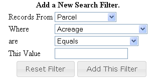
If you have specific criteria that you need to search, but cannot be satisfied by the above two methods you can create your own
query using the custom search dialog.

The choices of the value and the type of query changes based on the way the data is stored in the database. For instance if
it is a numeric field, you will be able to search equal to, greater than, less than, etc and if it is a date you will be able to choose before, equal to or after a date.

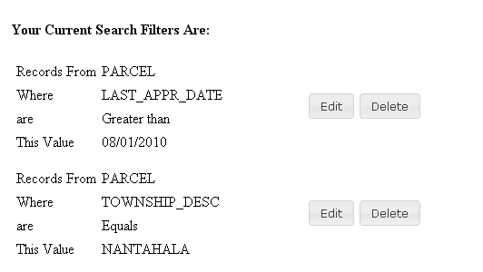
A list of the criteria will appear below the input dialog. You can modify or remove the criteria by clicking on the button in the list.

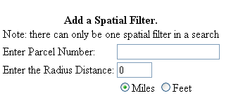
There can only be one spatial search per search which currently is a specified distance from a parcel.
Since all searches get translated into the custom search, when you pick Refine Search Criteria button on the Search Page, you will be rerouted to the Custom Search Page.
Managing Search Results
By default the search results page display up to 20 records at a time. You can increase the number of records per page with the page size drop down list at the bottom of the page.
By default the search results are sorted alphabetically by the PIN field. To change the sort order, click on the column heading in the results grid. If you want to sort in descending order click the same column a second time.
Use the navigate buttons at the bottom to navigate through the pages of the search results. You can jump to a page using the Goto drop down button.